The british offocial system use a gridshift methods to convert positions, which must be manually added (either OSTN15 or OSTN02)
You can find the grids on the UK Ordnance Survey website :
https://www.ordnancesurvey.co.uk/business-government/tools-support/os-net/for-developers
https://www.ordnancesurvey.co.uk/business-government/tools-support/os-net/format
1/ POSPac settings :
Under the export settings, please make sure to replicate the below entries.
The selection of OSGM15 will allow to be in the correct vertical system.

The Mapping Frame must be changed into ETRS1989, at epoch 1989.0, as it is the reference frame on which OSGB is based for its conversion.
Export your sbet file.
2/ CloudStation settings :
As a pre-requisite, please download the OSTN grid shift - this needs to be copied in your CloudStation installation.
The grid shift files can be obtained here : https://www.ordnancesurvey.co.uk/business-government/tools-support/os-net/for-developers
Under 'Everything you need' you have NTv2 format files (28Mb) leading to the below download : https://www.ordnancesurvey.co.uk/documents/resources/OSTN15-NTv2.zip
Once downloaded, please extract and copy the two .gsb files to the CloudStation folder
C:\Program Files\YellowScan\CloudStation\proj\share
Once copied it should look like this including the x2 OSTN15 grid shifts.

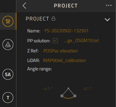
Now, to generate your lidar data, please make sure your project settings are set with the correct sbet file with the Z ref entered at POSPac elevation.
Run Strip adjustment, Terrain, eventually Colorization and once happy with the point cloud extraction, in the export tab, please change the export settings as below :
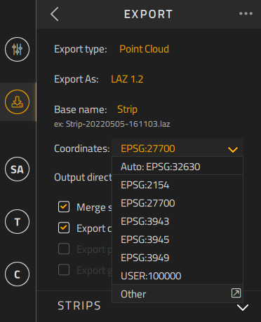
Select 'other' and make sure : i/ you define the folder path where you copied the 2 gsb files under 'Manage grid-shift search paths' ii/ search for the EPSG 27700 projection code


Once these settings have been entered, you can click 'export'.
Please mind you that the export process is fairly lengthy so please be patient. It is inherent to the use of NTv2 grids.